| ||
| Landslide hazard estimation image can be created by land cover information derived from SPOT/XS and DEM (Digital Elevation Model) of 10 meters ground resolution. Color composite of land cover change, disaster damaged area and hazard estimation are shown on the 3D image. (Yellow and Blue: Developed area, Red: Damaged area by landslide, Brown: High risk hazard estimated area) (Processed : HIT, SPOT image : NASDA(C)CNES1999) |
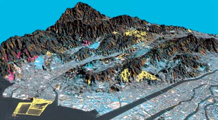 |
| Landslide hazard estimation 3D satellite image (Hiroshima City) |